
Land shopping in Fairbanks based on the inversion layer
Saturday, October 25th 2014
I’ve lived in Fairbanks Alaska as my primary location since starting my computer science degree with UAF back in 1996. This coming Winter will be my 18th Fairbanks winter; 8 of which are in a house Julie and I bought in University West.
A neat feature of winter in Fairbanks Alaska is the inversion layer. Fairbanks is in a low elevation area ringed by hills. This creates the opportunity during winter for a puddle of cold air to collect over Fairbanks. Fairbanks has very low winds so this puddle of cold air will sit on top of us for weeks at a time.
What is going on here is the a very cold puddle of air sits on parts of Fairbanks. This means I can drive to work from inside the puddle and as I go up the hill on campus the temperature will increase by up to 10 or 15 degrees. When it is -25 at home -15 at work feels much more pleasant.
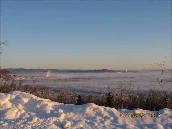
You can see the effect in this picture from the Alaska DEC
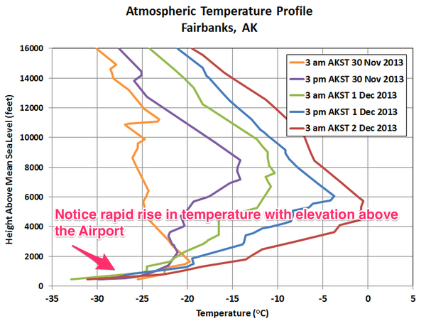
There is plenty of research around this problem due to the air quality issues in Fairbanks. A Fairbanks blogger Richard James - ak-wx had a nice article on a specific extreme inversion with the following temperature profile example:
Looking at a few random air profiles based from a sensor at the Fairbanks airport I came up with my own gut rule to play around with:
You can get a noticeable improvement in winter temperatures during inversions by being above 30 meters from the airport.
This conclusion is all not very scientific at all.
Get a DEM
I had Mitch at GINA toss a copy of the Fairbanks Northstar Borough’s LiDAR derived bare earth DEM on a drive for me. This came in the form of a single band GeoTIFF in Alaskan Albers equal area projection. The single band gave me the heights of areas in feet above sea level.
airport = 434       # feet
west_ridget = 602   # WRRB area
lower_campus = 523  # Julie's office
inversion = 532     # 30m above airport
DEM extract
Extracting just Chena Ridge, University West and Campus from the broader FNSB LiDAR derived bare earth DEM model.
gdal_translate -a_nodata 0 \
  -projwin 283783.787568 1669559.68581 293314.224471 1660196.18332 \
  -of GTiff merged_dem.fnsb.2010.tif fnsb.2010.dsm-extract.chena_ridge-uwest-campus
A hillshade for giggles:
gdaldem hillshade fnsb.2010.dsm-extract.chena_ridge-uwest-campus \
fnsb.2010.dsm-extract-wf-hillshade -z 1.0 -s 1.0 -az 315.0 -alt 45.0 -of GTiff
Lot for sale test Chena Ridge:
Julie looked up to see what lots are for sale in the Chena Ridge area and found one at 2585 Allen Adale road.
2585 Allen Adale Rd, Fairbanks, Alaska
From the DEM we find it is barely above the Dayne’s simple inversion layer of 540 at a height of 548. Better than University West but not optimal.
A mask
This is fun but find a spot and checking each one manually against the DEM is too much work. I want a ‘this is the cold area’ mask. Using QGIS’s Raster Calculator against the DEM extract I did a simple calculation of:
"fnsb.2010.dsm-extract@1" < 540
Creating the following mask effect:

Magic sauce
The next steps let me make this a bit more useable:
- convert raster mask to a vector
- simply the vector from 20K+ polylines to 2k polylines
- convert from EPSG:3338 to EPSG:4326 (google)
- convert shapefile to geojson
- upload to GitHub’s Gist system
By creating a EPSG:4326 GeoJSON as a Gist over at https://gist.github.com/dayne/bf2364c4faa3e17a6499 I could then have the following embedded map here:
Ground Truthing
Over this coming winter I’ll try and remeber to pay attention when the cold starts and see if this whole dance holds up against reality.